
Emergency Radiation Mapping
On this page
Overview
Under the Federal Nuclear Emergency Plan, Natural Resources Canada (NRCan) has a commitment to provide emergency response radiometric surveying. The Emergency Radiation Mapping (ERM) project is responsible for assembling a response group, deploying the remote sensing units, and providing technical expertise, as required.
Since 2002, with the support of the Chemical, Biological, Radiological-Nuclear and Explosives Research and Technology Initiative, the ERM project has developed and demonstrated world-leading ability to detect, identify and delineate radioactive materials in remote, urban and marine environments.
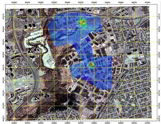
The highly sensitive survey system is autonomous and can be quickly mounted in an aircraft or in a truck to measure gamma radiation spectra and neutron fields and to transmit this data to a ground-based receiving station. NRCan scientists provide real-time interpretation of the data. The experience of the NRCan team in airborne geophysical mapping is put to use in producing geo-referenced maps of the radiological dose, overlaid on a road map or satellite image. This information can be interpreted to provide source location, and if possible, isotopic identification and relative strength.
Contact information
| Mailing Address | Phone, Fax and Email |
|---|---|
|
Dr. Laurel E Sinclair, ERM Project Lead Natural Resources Canada 601 Booth Street, 5th Floor, Room. 571 Ottawa , ON Canada K1A 0E8 |
Phone:
(613) 947-3337 Fax: (613) 996-3726 Email: lsinclai@nrcan-rncan.gc.ca |