
How can we tell when a volcano will erupt and how do we prepare for an eruption?
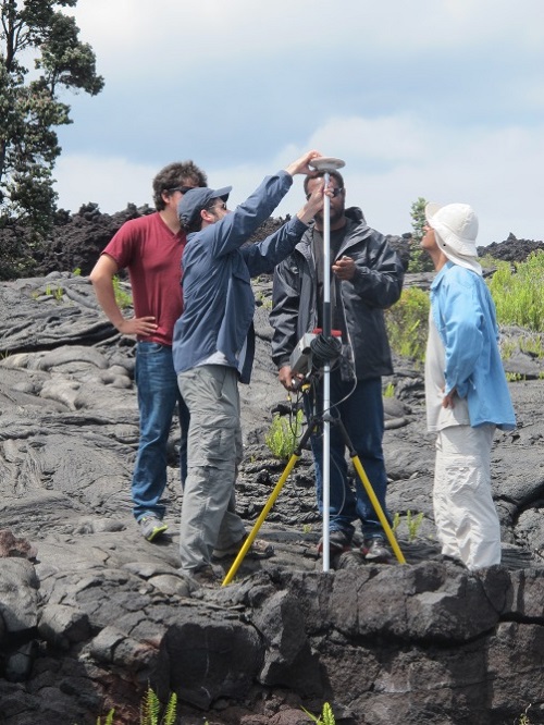
a GPS campaign
Students conduct a GPS campaign to measure ground deformation on the flank of Kilauea, Hawaii, 2013.
Volcanic eruptions are almost always preceded by days, weeks, months, or years of warning activity which reflects the movement or pressurization of magma, especially at volcanoes that have not erupted in centuries or longer (like all of Canada’s volcanoes). These signs of unrest include earthquakes (which may be detectable only with seismographs), ground deformation (which may be detectable only with surveying equipment, GPS instruments, or satellite imagery), gas emissions, and heat anomalies, as well as gravity, magnetic, and geoelectrical phenomena. These phenomena are readily detectable, and can thus be used in volcano monitoring – the systematic collection, analysis, and interpretation of data before, during, and after eruptions, for the purpose of making short-term (days to weeks) forecasts of eruptions or changes in eruptions. The ability to monitor volcanoes effectively is crucial to reducing risks from volcanic hazards.
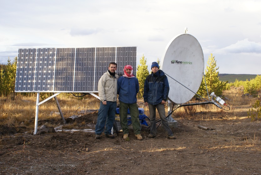
A seismic monitoring station
Newly-installed seismic monitoring station near Nazko cone, British Columbia, 2007.
There are many recent examples of eruptions where volcano monitoring data were used to successfully forecast an eruption. The forecast of the 1991 eruption of Mount Pinatubo (the second largest eruption in the twentieth century) is an excellent example: it has been estimated that tens of thousands of lives were saved due to evacuations. Removal of property (especially vehicles and aircraft) from areas around the volcano also saved at least 250 million U.S. dollars, and these savings far outweighed the costs of monitoring. The Mount Pinatubo eruption is a particularly noteworthy example of successful forecasting because the volcano was not monitored prior to the unrest that was first observed three months before the cataclysmic eruption. Volcano monitoring conducted during times when no unrest is occurring is useful because it establishes a baseline for the volcano’s behaviour, however, even where there is little or no pre-unrest monitoring, short-term forecasting may be successful, as was the case at Pinatubo.
Every volcano is different, and the processes that dictate whether an eruption will occur, how big it will be, what hazards will be present, and what areas will be affected, are complex. Sometimes a volcano will experience low-level unrest that lasts for weeks or months but does not culminate in eruption (as was the case during the Nazko region seismic swarm in central British Columbia in 2007). At other times, days, weeks, or months of escalating unrest will be followed by an eruption (as was the case at Mount St. Helens in 1980). Sometimes a volcano will continue to erupt at short intervals for many years (as has been the case with the Soufrière Hills volcano on Montserrat, which has been erupting since 1995). Sometimes a volcano will experience escalating unrest that ceases without eruption; such situations can be especially problematic because the making of an unfulfilled eruption forecast (a “false alarm”) can cause scientists to lose credibility. Volcano monitoring is still a new and evolving science, and there is always some uncertainty in a forecast, both because of the limits of available knowledge and the inherent uncertainty in natural systems.
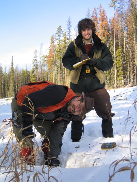
Nazko gas monitoring
Scientists measuring soil gas content near Nazko cone, British Columbia in 2007.
In Canada, there is no ongoing monitoring at individual volcanoes because eruptions are so infrequent. However, Natural Resources Canada’s Canadian National Seismograph Network (CNSN) currently monitors volcanic regions in British Columbia and the Yukon and can detect very small earthquakes. If unrest were detected near a Canadian volcano, NRCan would respond by providing additional targeted monitoring of seismic activity, ground deformation, gas emissions, and other phenomena in order to find out what was happening, and would prepare hazard maps and work closely with emergency planning agencies to ensure that accurate hazard information was available. During the 2007 Nazko seismic swarm in central British Columbia, which lasted two months and did not lead to an eruption, NRCan installed additional seismic stations, took soil gas measurements to look for volcanic gas emissions, conducted field reconnaissance, and prepared a preliminary hazard map.
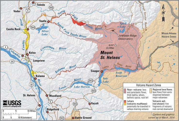
Mount St. Helens hazard map
United States Geological Survey simplified hazard map for Mount St. Helens, Washington, showing the potential impact areas for ground-based hazards during a volcanic eruption. Areas that might be affected by volcanic ash are not shown.
Volcano monitoring looks at the day to day behaviour of a volcano. In contrast, geologic mapping and other studies at dormant volcanoes (conducted when unrest is not occurring) can help establish the past behaviour of a volcano, the frequency of eruption, the sizes of past eruptions, and the areas affected by past eruptions. The best key to what a volcano will do in the future is what it has done in the past. Computer modelling can also help predict areas that will be affected by events (such as lava flows, pyroclastic flows, and lahars) of different sizes in the future. All of this information can be used to generate long-term forecasts of volcano behaviour (forecasts on a time scale of decades to centuries or more) and to assist in hazard assessments and hazard mapping. For example, if Volcano X has erupted 10 times during the last 1000 years, we would say that it has a 100 year return period, and that the average annual probability of an eruption is 1 in 100. This long-term forecast of 1 eruption every hundred years does not tell us what year an eruption will occur, or that because an eruption has not occurred for 100 years that an eruption next year is guaranteed – but it does tell us that an eruption is more statistically probable at Volcano X than at a volcano that has only erupted once in the last 1000 years. Hazard maps and assessments, and long-term forecasts, can be very useful for emergency planning and for prioritizing volcano research and monitoring resources. Hazard assessment, hazard mapping, and volcano monitoring are all important in reducing the risk from volcanic hazards